• Link to Facebook
  • Link to LinkedIn
  • Italiano Italiano Italian it
  • English English English en
  • Français Français French fr
Tel (+39) 055 674104 E-mail geomap@geomapsrl.it
Geomap S.r.l.
  • Home
  • Activity and type of clients
    • Land
    • Environment and Cultural Heritage
    • Applied Geology and Hydrogeology
    • Energy and Mineral Resources
    • Professional Training
    • Investigations and surveys
  • About us
    • Our History
    • Geomap Mission and Vision
    • Professional and Technical Staff
      • Curriculum vitae
    • Portfolio Clients
    • Publications
  • Projects
  • Download
    • Brochure
  • Contact Us
  • Click to open the search input field Click to open the search input field Search
  • Menu Menu

Po Project

  • Project Name
  • Geomorphological characterization of the Po river bed and floodplains, from the confluence of the Dora Riparia (Turin) to Pontelagoscuro (Ferrara)
  • Country, Location(s)
  • Italy, Po Valley, across the regions of Piedmont, Lombardy, Emilia-Romagna and Veneto
  • Client(s)
  • Po River Basin Authority, Parma / SGI – Studio Galli Ingegneria, Padua
  • Aims of the Project
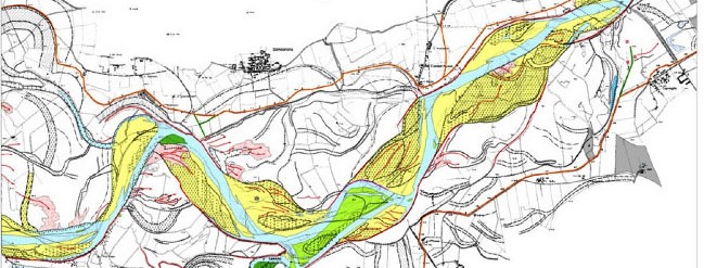
  • Analysis of the modifications of the Po river bed, over approximately 480 km of course, with particular reference to the variations of natural thresholds and banks, to the effects of the floods of 1994 and 2000 and to the interactions between dead hydrography and main levees
  • Contract Holder(s)
  • Geomap Srl
  • Staff
  • 2 geologists photointerpreters, 1 GIS expert
  • Project Activities
  • The morphological analysis of the segment between the confluence of the Tanaro and Pontelagoscuro was carried out between 1979 and 2002, since the previous morphological changes had already been studied by a former project, carried out by Geomap for another Client in 1982.
    For the upstream segment of the Tanaro, the study was based on all the historical documentation available, either cartographic or air-photographic.
    Morphological elements were identified by means of aerial photos taken in 1995, 2000 and 2002, which, respectively, allowed the recognition of the effects of the flood of November 1994, the extension of the waters during the October 2000 flood and, in the latter case, the consequences of the above event and the situation of the bed during the exceptional low water level of 2002.
    The evolution of the river bed was reconstructed by comparing the situations recognized by photointerpretation with thematic and topographic maps of 1979 and 1988, respectively.
    The morphological elements necessary for the characterization of the flood zones were obtained partly from aerial photos, but mostly from AIMA orthophotos and topo maps of various origins and scales (IGMI and Regional Technical Map – CTR), which were also used as the basis for the presentation of the results.
    A GIS environment was employed to manage all the acquired data as well as for the production of layouts and hardcopy maps.
  • Start (month/year)
  • September 2003
  • End (month/year)
  • September 2006

Progetti

  • Support for building design in the earthquake zones of Central Italy: Amatrice Cemetery and “Majorana” School (Rieti)2019
  • Definitive project for the upgrading of S.S. 372 to 4 lanes2016
  • Zarema Dam, Ethiopia2013
  • Geostructural studies by photointerpretation in support of geothermal exploration2011
  • “Val d’Agri” Concession, geological photo-interpretation: geo-structural study2011
  • Analysis of susceptibility to landslide phenomena (Franarisk project)2008
  • Po Project2003
  • Plan National de Cartographie Géologique (PNCG)2003
  • DUSAF project: updating of land use and land cover in the Lombardy Region2001
  • Photointerpretation aimed at the identification of risk areas for the possible presence of WWII unexploded aerial bombs2000
  • Hal Saflieni Hypogeum, Malta1992
  • Evolution of industrial areas1988
  • Search for groundwater in rocky substrate by photointerpretation (Hydraulique Villageoise)1983
  • Dam on the Rio Guavio, Colombia1981

Geomap Srl – Engineering company

Viale Eleonora Duse, 12
50137 Florence, Italy
phone +39 055 674104
geomap@geomapsrl.it
VAT number, Tax code 04108890486

9001 ISO Quality certification
Certificazione UNI EN ISO 9001

© Copyright - Geomap S.r.l. Società di ingegneria, tutti i diritti riservati
Design & Development di iKreativo | Powered by WordPress
  • Link to Facebook
  • Link to LinkedIn
  • Privacy Policy
  • Cookie Policy
Link to: Plan National de Cartographie Géologique (PNCG) Link to: Plan National de Cartographie Géologique (PNCG) Plan National de Cartographie Géologique (PNCG) Link to: Analysis of susceptibility to landslide phenomena (Franarisk project) Link to: Analysis of susceptibility to landslide phenomena (Franarisk project) Analysis of susceptibility to landslide phenomena (Franarisk project)
Scroll to top Scroll to top Scroll to top